Join our Facebook Group
Sngine by ScriptsTribe
Join

Diretório

Conheça novas pessoas, crie conexões e faça novos amigos

Publicações

  • WWW.FOXWEATHER.COM
    Watch: 8th North Carolina beach house to collapse caught live on FOX Weather
    BUXTON, N.C. Another house along the beach in North Carolina's Outer Banks collapsed into the ocean on Thursday afternoon during relentless surf supercharged by dual offshore hurricanes, making it the eighth home in just three days to fall.Tuesday began the fury of collapses, as hurricanes Imelda and Humberto brought large waves to the Outer Banks.Six homes fell Tuesday, followed by a seventh on Wednesday night.SEE IT: 7 HOMES ALONG NORTH CAROLINA'S OUTER BANKS COLLAPSE INTO ATLANTICFOX Weather Correspondent Katie Byrne was there as the eighth home collapsed into the Atlantic on Thursday.WATCH: DRONE VIDEO SHOWS SCENE OF 7 HOMES THAT CRUMBLED INTO THE ATLANTIC THIS WEEK"You hear the creaking, the snapping sounds of the wood. And then just in a matter of seconds, the house fell down onto its pilings," Byrne said, recapping the moment. "Its now the eighth one to add to this field of debris thats now growing."Dozens of people gathered on the beach to watch the house sway in and out of the ocean, pushing up against another house in the background.WHAT TO EXPECT FOR FINAL 2 MONTHS OF ATLANTIC HURRICANE SEASONPiles of debris littered the beach from other collapsed houses."It's unreal. I'm actually speechless, and it's really, really sad what's happening to this community, to these homes," Adrianne, who lives in Buxton, told Byrne. "People have spent their entire lives vacationing here. It really is paradise, but there's always a price to pay."While Byrne was speaking to Adrianne, the first story of the home collapsed into the ocean and a large wave splashed up onto the beach, carrying the home with it.HOW TO WATCH FOX WATHERByrne said offshore buoys indicated waves up to 14 feet. High Surf Advisories remain in effect through Saturday morning.Cape Hatteras National Seashore said it will deploy about two dozen staff to Buxton on Friday to contribute to the significant cleanup efforts associated with the recent house collapses.
    Like
    1
    0 Comentários 0 Compartilhamentos 694 Visualizações 0 Anterior
  • WWW.FOXWEATHER.COM
    Watch: Drone video shows scene of 7 homes that crumbled into the Atlantic this week
    BUXTON, N.C. A recently recorded drone video showed the devastating scene of the oceanfront homes in Buxton, North Carolina, that crumbled into the Atlantic starting Tuesday evening.So far, seven unoccupied homes have collapsed on the Outer Banks due to years of beach erosion and powerful wave action caused by hurricanes Imelda and Humberto.HOW TO WATCH FOX WEATHERThe first five homes collapsed within 45 mins on Tuesday, while the sixth home was decimated later that night. The seventh house collapsed late Wednesday night.Officials have reported that no one has been injured during the collapses."All the houses are taking a beating. It's devastating," photographer Jenni Koontz told FOX Weather. "I think the damage is unmeasurable at this point. As a local that lives here, it's heartbreaking, not only for the homeowners, but for the community where we live."As of Thursday, High Surf Advisories remain in effect while Coastal Flood Warnings remain in effect through Friday.IMELDA REMAINS POWERFUL POST-TROPICAL STORM AFTER BASHING BERMUDA WITH POWERFUL WINDS, MASSIVE WAVESThe National Park Service (NPS) urged visitors to stay away from the site of the collapsed homes and to use caution due to the presence of potentially hazardous debris."I don't know how this is going to be cleaned up very quickly. There's a lot of debris," Koontz said. "I think we're just getting started. I think the rest of the week is going to be just as intense, if not more. We're going to have more houses falling in for sure."
    Haha
    1
    0 Comentários 0 Compartilhamentos 657 Visualizações 0 Anterior
  • WWW.FOXWEATHER.COM
    Great Smoky Mountains National Park road reopens days after 'major' landslide
    GATLINBURG, Tenn. The Gatlinburg Bypass in Great Smoky Mountains National Park in Tennessee is back open four days after a landslide closed a large section of the road.The national park announced the reopening on Tuesday, saying 140 truckloads of debris were removed from the road following Saturday's landslide.Heavy rain triggered the landslide, leaving 150 feet of the bypass covered with mud, trees and rocks.Photos of the Gatlinburg Bypass on Saturday showed some of the extent of the debris on the road.DRAGON BRAVO FIRE IN GRAND CANYON 100% CONTAINED AHEAD OF NORTH RIM REOPENINGThe national park posted an update after the closure Monday, letting people know the road was still closed, but progress was being made.By Tuesday, Great Smoky Mountains National Park said the road was back open, sharing photos of the road cleared of mud and debris."After a major landslide on Saturday, Sept. 27, the Gatlinburg Bypass is now reopened," the park said.CHUNKY CHAMPION OF FAT BEAR WEEK 2025 CROWNED IN ALASKA"The park extends its thanks to the City of Gatlinburg, Sevier County, and the City of Sevierville for their swift and valuable assistance in supporting the National Park Service crews in the response to this event," Great Smoky Mountain National Parks said.The national park remained open during the road closure.
    Like
    1
    0 Comentários 0 Compartilhamentos 652 Visualizações 0 Anterior
  • WWW.FOXWEATHER.COM
    See it: 7 homes along North Carolina's Outer Banks collapse into Atlantic
    BUXTON, N.C. A drone video showed homes along North Carolina's Outer Banks collapsing into the Atlantic Ocean after massive waves kicked up by hurricanes Humberto and Imelda pounded the coast.Seven homes have now collapsed into the waves this week in Buxton, North Carolina, according to Cape Hatteras National Seashore the most recent happening Wednesday night around 8 p.m.That's after at least five homes collapsed all within 45 minutes, starting about 2 p.m. Tuesday. A sixth home was destroyed by the water later that night, according to Cape Hatteras National Seashore officials.No one has been injured during the collapses. FOX Weather Correspondent Katie Byrne reported that the homes in the area were recently declared uninhabitable.HOW TO WATCH FOX WEATHERIncluding this most recent spate of collapses, the National Seashore said 19 privately-owned houses have collapsed on Seashore beaches since 2020, the result of an ongoing battle with coastal erosion.The drone video recorded by Jenni Koontz of Epic Shutter Photography showed two of the seven homes collapsing into the water, crashing into other properties and littering the beach with debris."It was insane. It sounded like bombs going off," local resident Hunter Hicks told Byrne. "Windows were cracking. Pylons were cracking. Houses were just washing all the way down the ocean. It's pretty bad here right now."DOWNLOAD THE FREE FOX WEATHER APPThree of the homes that collapsed Tuesday afternoon were neighbors on Cottage Avenue in Buxton, while two other neighboring homes fell on nearby Tower Circle Road. The two additional homes that collapsed Tuesday night and Wednesday night were also on Tower Circle Road."I don't know how this is going to be cleaned up very quickly. There's a lot of debris," Koontz said. "I think we're just getting started. I think the rest of the week is going to be just as intense, if not more. We're going to have more houses falling in for sure."Both Humberto and Imelda have been swirling across the Atlantic, kicking up powerful waves that have been slamming coastal communities in the Bahamas, Bermuda and the entire U.S. East Coast over the past several days.
    Love
    1
    0 Comentários 0 Compartilhamentos 705 Visualizações 0 Anterior
  • WWW.FOXWEATHER.COM
    Dragon Bravo Fire in Grand Canyon 100% contained ahead of North Rim reopening
    GRAND CANYON, Ariz. The Dragon Bravo Fire, a wildfire that had raged in Grand Canyon National Park for nearly three months, is finally contained, officials announced on Monday.The Dragon Bravo Fire began July 4, when lightning ignited sparks in the North Rim of the Grand Canyon. Since then, the wildfire has burned over 145,000 acres, or over 200 square miles, and damaged or destroyed nearly half of all North Rim structures.Officials said the wildfire is no longer at risk of spreading. However, some smoke may still be visible as unburned fuels deep inside the fire perimeter continues to burn.This containment comes just ahead of the partial reopening of the North Rim of the Grand Canyon on Oct. 1, over two months after it had shuttered due to the Dragon Bravo Fire, along with a second wildfire burning at the time, the White Sage Fire.GRAND CANYON NORTH RIM BEGINS TO REOPEN AFTER DRAGON BRAVO FIRE DESTRUCTIONSelect areas reopened in the North Rim include Highway 67 to the W1 road, along with Cape Royal Road.Officials said this gives the public access to Point Imperial, the northernmost point in the park and the highest point on the rim of the Grand Canyon, and Cape Royal, one of the only spots on the North Rim with views of the Colorado River. The reopened areas will be open from sunrise to sunset, as overnight use will be prohibited.Other areas that will reopen are Fire Point and Swamp Ridge campsites, officials added. These are the only reopened areas on the North Rim where overnight use will be permitted.The open areas will be accessible through Nov. 30, or when the park sees its first major snowfall whichever happens first.All other parts of the North Rim will remain closed indefinitely due to safety concerns and recovery efforts following the Dragon Bravo Fire.This includes the North Kaibab Trail, which is the most difficult of the major inner canyon trails at Grand Canyon National Park, the NPS said. It experienced extensive damage from the wildfire and now has rockfalls along the upper section of the trail.National Park Service officials asked park visitors to be careful when venturing into the newly reopened areas of the park, as dead standing trees, the potential for flash flooding and other hazards remain.They also stressed the need to be self-sufficient when visiting the park, as the reopened areas have no power, running water, cell service or visitor services. Because of this, visitors must bring their own food, water and supplies.HOW TO WATCH FOX WEATHERVisitors should also prepare their vehicles, which should be no longer than 22 feet, and fill up their tanks, as no fuel is available in the park, according to the NPS. Additionally, drivers should be vigilant of the weather and road conditions this time of year, as snow and icy roads are possible.Officials also asked visitors to mind the crews that are actively working on recovery efforts within the park.The Dragon Bravo Fire is the 10th-largest wildfire on record in Arizona, according to FOX 10 Phoenix. It destroyed structures, such as the historic Grand Canyon Lodge, in Grand Canyon National Park.In addition to the partial reopening of the Grand Canyon, the containment of the Dragon Bravo Fire is allowing for more areas of the Kaibab National Forest to reopen.More than 25,000 additional acres of forest north of the Grand Canyon National Park boundary between Saddle Mountain Wilderness and Highway 67 will now be accessible to the public in Kaibab National Forest.
    Like
    1
    0 Comentários 0 Compartilhamentos 729 Visualizações 0 Anterior
  • WWW.FOXWEATHER.COM
    6 homes collapse as waves from hurricanes Imelda, Humberto slam North Carolina's Outer Banks
    BUXTON, N.C. Six unoccupied homes have collapsed and been swept into the Atlantic Ocean along North Carolina's Outer Banks since Tuesday as powerful waves from hurricanes Humberto and Imelda slam the Southeast coast.Five of the six collapses in Buxton occurred within about 45 minutes Tuesday afternoon, starting about 2 p.m. ET, according to Cape Hatteras National Seashore officials. There are no reports of any injuries."It was insane, it sounded like bombs going off," local resident Hunter Hicks told FOX Weather Correspondent Katie Byrne. "Windows were cracking, pylons were cracking, houses were just washing all the way down the ocean. It's pretty bad here right now."Three of the homes that collapsed Tuesday were neighbors on Cottage Avenue, and two other neighboring homes fell on nearby Tower Circle Road around the same time."All the houses are taking a beating. It's devastating," photographer Jenni Koontz told FOX Weather. "I think the damage is unmeasurable at this point. As a local that lives here, it's heartbreaking, not only for the homeowners, but for the community where we live."She said the massive debris piles have merged, making it difficult to know what debris belonged to what house."I don't know how this is gonna be cleaned up very quickly. There's a lot of debris," Koontz said. "I think we're just getting started. I think the rest of the week is going to be just as intense, if not more, we're gonna have more houses falling in for sure."Hicks said there were people renting some of those homes just a month ago, but had to evacuate ahead of the storms."It's very upsetting," Hicks said.Both hurricanes are steering clear of the Eastern Seaboard, but powerful waves are expected to batter the coast through the week.HURRICANES HUMBERTO, IMELDA CREATE DEADLY RIP CURRENTS, TRIGGER FLOOD THREAT FOR US EAST COASTCoastal Flood Warnings remain in effect for Ocracoke Island until Friday evening for ocean inundation of 2-3 feet above ground level, with locally deeper waters with higher wave action."(This will result) in an elevated threat of property damage," the National Weather Service warned. "Flooding will likely extend inland from the waterfront threatening some homes, businesses and critical infrastructure."North Carolina's Highway 12 was shut down along the north end of Ocracoke Island as increasing ocean overwash has made travel conditions dangerous along the highway, North Carolina Department of Transportation officials said.With several more days of heavy surf in the forecast, Koontz said more vulnerable homes will likely be lost this week."Yeah, so those houses are all hanging on by a thread," Koontz said, pointing to homes still standing yet now consistently perched over the surf. "A lot of them are missing a lot of pilings that are holding them up, and they're slowly losing more and more. Some of the homes are braced and a little bit stronger, but for the most part, they're all vulnerable. And this beach is just getting started with the weather. So I imagine there's going to be many more that fall."
    Love
    1
    0 Comentários 0 Compartilhamentos 761 Visualizações 0 Anterior
  • WWW.FOXWEATHER.COM
    Duke Energy lineman recounts Helene response, recovery in Chimney Rock 1 year later
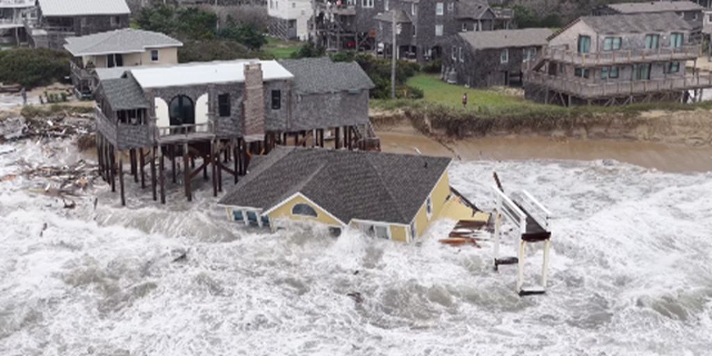
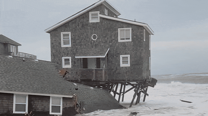
    CHIMNEY ROCK, N.C. When Hurricane Helene turned rivers and streams into deadly walls of water across western North Carolina one year ago, 100% of Duke Energy personnel were involved in restoring power to 2.7 million customers.A year later, after repairing more than 350 substations damaged by Helene, Duke Energy linemen, many of whom lived and worked in these communities, are recalling the devastation they saw in the wake of the flooding.Linemen supervisor Miles Bell has been through 12 hurricane seasons with Duke Energy. He spent about two months in Chimney Rock, North Carolina, after Helene, not far from where he lives in western North Carolina.HISTORIC BILTMORE VILLAGE SHOWS STRENGTH, RESILIENCE IN RECOVERY 1 YEAR AFTER HURRICANE HELENE"This was by far the worst, just as far as devastation to our equipment, but then this one was so bad cause it was paired with just the devastation of the landscape, people's personal property," Bell told FOX Weather. "Places were just unrecognizable. I mean literally, (I) drove past some of this stuff for 30 years and I don't even remember what it used to look like. It's changed so much."Mountainous regions of western North Carolina saw 20-30 inches of rain between Sept. 25 and 27, 2024. The U.S. Geological Survey documented more than 2,000 landslides, with the majority in this region. Hurricane-force winds downed trees with gusts over 90 mph recorded in Yancey County. Tragically, 86 people were killed by Helene's impacts in North Carolina, most from flooding.Chimney Rock was among the hardest hit communities because of the landscape. Roads were gone. Department of Transportation crews have started from the ground up in some areas."It's just a river gorge, and there were places where we had landslides, and I mean you couldn't hardly even hike," Bell said. "It was just like, rock cliff on either side and kind of impassable. We had to wait a bit for things to become safe enough just to traverse. And then we ended up utilizing helicopters and a lot of different things to get the work done."LINEMEN SPENT WEEKS AWAY FROM HOME RESPONDING TO HELENE, MILTONCrews were able to get nearly everyone restored within two months after Helenes historic flooding.According to Duke, storm repairs from Helene included more than 60,000 locations. Crews ran 1,700 miles of wire enough to cover from Charlotte, North Carolina, to Denver, Colorado.Bell said that a year later, many areas look back to normal, but Chimney Rock, or anywhere near the river banks, are still under intense recovery."The30,000-foot view, you really wouldn't know. Its isolated little pockets," Bell said. "There are still places that are just ravished and, not so much from a power standpoint, because we got everybody that could have power. We got that taken care of."Chimney Rock still looks like a "war zone," Bell said, due to the rock slides and damage from the river flooding. The North Carolina Department of Transportation had to work from the bedrock up.SOUTH CAROLINA MAN CARVES 'STORM BOWLS' OUT OF TREES BROUGHT DOWN BY HELENEOrganizations continue to rebuild the small communities most devastated by Helene."It was through all the heartbreak and the devastation, it really was powerful to see everybody lifting one another up and kind of teaming up, partnering together," Bells said.This hurricane season, which has spared the U.S. a direct hit so far, Bell said he is much more prepared."Being a lineman you kind of always pay attention to the weather," Bell said. "I mean everyday, weather trumps everything. It doesn't matter what your plans are weather trumps it all. So we're all kind of slaves to the weather. I've always paid attention to it, but now I would say my awareness is just a tick higher."
    Love
    1
    0 Comentários 0 Compartilhamentos 639 Visualizações 0 Anterior
  • WWW.FOXWEATHER.COM
    Arizona flash flooding leaves at least 4 dead as 1,000 propane tanks get swept downstream
    GLOBE, Ariz. At least four people have been killed, and a dangerous hazmat situation unfolded in central Arizona when devastating flash flooding tore through communities like Globe, Miami and Scottsdale over the weekend.Details on those who were killed have not yet been released, but Gila County officials said in a news release that several people remain unaccounted for after the flooding there, in addition to the deaths.HOW TO WATCH FOX WEATHERIn Scottsdale, police said a man who was reported missing on Friday was found dead after floodwaters there began to recede.According to a report from FOX 10 in Phoenix, the Scottsdale Fire Department responded to reports that a vehicle was "partially submerged in 8 to 9 feet of fast-moving water."Crews shut down the road, and a search began for anyone who may have been inside the vehicle, but no one was found. The decision was made to monitor the vehicle overnight as the water levels were dropping.According to the report, as officials worked to locate the vehicles owner, family members reported 38-year-old Ander Pallares Polanco missing on Friday evening.The next morning, first responders searched the vehicle again, and a body, later identified as Polanco, was found pinned beneath a bridge, submerged in 5 to 6 feet of water.DOWNLOAD THE FREE FOX WEATHER APPGila County officials said nearly 1,000 propane tanks were also swept away by the raging floodwaters, creating a hazardous situation, and several roads were closed due to high water.Hazardous materials teams swarmed the area to begin cleaning up and monitoring air quality, officials said."Historic Downtown Globe is currently unsafe, with compromised buildings as well as hazardous chemicals and debris, including propane tanks," Globe city officials posted on Facebook. "For your safety, please stay out of the area until further notice."Officials said in addition to hazmat teams, over 100 additional search and rescue crews were in the area looking for any others who may have been swept away.MONSOON MOISTURE TRIGGERS FLOODING IN PHOENIX AREA"As you are all aware of, tonight our community has experienced an unthinkable, devastating flood event," Globe Mayor Al Gameros posted on social media. "Our primary objective tonight is search and rescue due to numerous vehicles that have been swept into the wash."Governor Katie Hobbs declared a state of emergency for Gila County following the monsoon flooding."Im heartbroken by the devastation in Gila county. My thoughts are with the families who have lost loved ones and the residents whose lives have been impacted,"Hobbs said in a statement. "This declaration is a commitment to the people of Gila County that Arizona will deliver every resource available to help. We will continue to work around the clock to ensure communities throughout Gila County that have been impacted by devastating flooding have the support they need to protect life and property."Video shot by Jaleka Jawara during the flooding shows multiple propane tanks floating through the waters raging through town, along with several damaged vehicles and flooded buildings.Globe was slammed by torrential rains from monsoon thunderstorms on Friday evening. A rain gauge at the Globe courthouse recorded 2.09 inches of rain in just 25 minutes.
    Love
    1
    0 Comentários 0 Compartilhamentos 801 Visualizações 0 Anterior
  • WWW.FOXWEATHER.COM
    Before-and-after satellite imagery shows destruction from Super Typhoon Ragasa
    TAIPEI, Taiwan Newly released satellite imagery shows the impacts from storm surge and flooding produced by Super Typhoon Ragasa as it passed through the Luzon Strait on a trajectory toward China.The images, released by Maxar, a space technology company based in Colorado, showed bridges destroyed, farmland inundated by floodwater and large swaths of southern Taiwan coated in thick debris.Many streets appeared to be covered by silt and mud as both lakes and streams overtopped their banks, raising concerns about the stability of infrastructure."Many of the streets in Guangfu remain covered with mud and silt and similar damage is seen in farms and fields along the outskirts of the city," Maxar stated. "Nearby, the Mataian Creek Bridge has been destroyed and washed away from the flooding."FLORIDA IDENTIFIES NEXT INVASIVE SPECIES THREATAccording to authorities in Taiwan, at least 17 people were killed and many more were missing after the powerful cyclone passed south of the island.Typhoon Ragasa developed east of the Philippines before becoming the world's strongest cyclone of the year with maximum sustained winds of about 165 mph.The Philippines, Taiwan and China reported widespread damage from the cyclone, with a combined death toll already at several dozen and many people still unaccounted for.In countries such as Taiwan, the countrys military was deployed to assist in search and rescue operations, setting up temporary shelters and airlifting supplies into isolated areas.In Hong Kong, schools and airports were closed as the worst of the weather moved from east to west across southern China.Significant flooding was also reported in China, particularly in Guangdong Province, but it was unclear if there were any confirmed reports of missing people or fatalities.Local officials continued to warn of possible landslides in mountainous terrain where the ground was already saturated.WAR TROPHY FROM GEORGE WASHINGTON'S ARMY DISCOVERED AMID BRITISH SHIPWRECKBefore the arrival of the cyclone, the government aided in moving millions out of the expected impact zone, which likely prevented a significant loss of life.Ragasa made its final landfall southwest of Hong Kong on Wednesday with winds on the order of 80-100 mph, but the threat of flooding and landslides was expected to continue well inland.The remnants of the cyclone were also expected to lead to heavy rainfall and flooding in northern Vietnam and Laos.
    Love
    1
    0 Comentários 0 Compartilhamentos 2KB Visualizações 0 Anterior
  • WWW.FOXWEATHER.COM
    See it: Tree set ablaze after lightning strike during Oklahoma thunderstorms
    SALLISAW, Okla. Lightning set a tree ablaze in flames as thunderstorms rolled through eastern Oklahoma on Tuesday, and it was caught on video."Most exciting part of today was this tree being nuked by lightning," the recorder of the video, @MesoHunter, said in the video caption.The video showed embers falling as large flames crept up the tree.LIGHTNING 5 TIMES STRONGER THAN AVERAGE SHREDS WEATHER RADAR IN NEW ZEALANDThe National Weather Service in Tulsa said on Tuesday that severe storms in Arkansas and southeastern Oklahoma posed the threat for large hail and damaging winds through the night.It's unclear if the fire spread to the base of the tree or when it was put out.
    Love
    1
    0 Comentários 0 Compartilhamentos 2KB Visualizações 0 Anterior